Importance of Landform Evolution

The present day forms of land surface (landform) are a result of different earth surface processes that operated over long geological times, landform is usually the first and easiest thing we observe when we study global change and the impacts of human activities on our environment and may contain important clues to past processes related to global change and human impacts. In order to be able to improve and maintain the sustainability of our environment and predict and reduce the impact of contemporary earth surface processes that lead to natural hazards (such as landslides), we need to have a basic understanding of the general configuration of landforms and of the surface processes and environmental factors involved in their formation and evolution. Landform evolution is an important aspect of earth sciences and involves complicated interaction among different physical processes and environmental factors, such as underlying rock structures, tectonics, rock types, climate and climatic changes, and human activities, all occurring over a wide range of spatial and temporal scales. However, because of the degree of complexity in spatial and temporal scales, long-term landform evolution cannot be observed directly. Further, the interacting processes involved are hard to infer from the limited temporal observations of present day forms.

Computer simulation is an ideal tool for understanding the complex effects of a variety of physical and geological processes that interact to influence landform evolution over geologic time scale. Yet the simulation models and the visualization and animation of their results usually require specialized software that is not easily accessible. This Web-based Interactive Landform Simulation Model (WILSIM) is designed to help you better understand landform evolution that can be accessed anywhere and anytime. The only requirement is an Internet connection and a standard Java enabled web browser. You will be able to explore and observe how landforms evolve as you change different parameters (such as rock erodibility, rainfall intensity, and/or tectonic uplift) interactively. But first, let’s briefly review some general concepts and principles of landform evolution.

What Factors Influence Landform Evolution?

One of the most commonly observed patterns of river systems is the branching pattern of dendritic drainage network (from the Greek dendrites). It ranges from the small scale of rill (formed by erosion on a newly exposed surface) to the continental scale drainages that evolved over long geological times (e.g., the Mississippi, the Amazon, the Congo, and the Yellow). Figure 1 shows some example of a dendritic drainage pattern. How do branching drainage networks get started and what controls their evolution?

Dendritic Drainage on the Western Plains


Dendritic Drainage Yemen

Figure 1 Left, Dendritic drainage pattern on the Western Plains
(oblique view from an airplane).
(Source: http://www.ametsoc.org/amsedu/WESWESSlides/
WESThumbnailHyperlinks/ch7/dendritic_drainage_pattern.htm)

Right, Dendritic drainage pattern in Yemen (space shuttle photograph).
(Source: http://www.solarviews.com/cap/earth/yemen.htm)

Overland flow (runoff) of waters with erosive potential is generated when the volume of water supplied from rainfall or snowmelt exceeds the infiltration capacity of the soils or substrate. For 
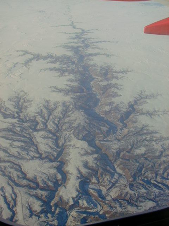
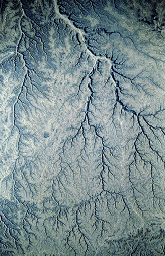
slopes developing in arid/semi-arid regions (sparse protective vegetation cover), rain splash erosion can be very effective. Infrequent but substantial rainfall events may be sufficient to generate runoff in which the shear stress of overland flow exceeds the shear strength of the surficial materials such that weathered or loose particles are eroded and transported down slope. Spatial variation in surface topography of the slope and texture of the slope sediments often leads to gulling for landscapes where low vegetation cover and root mass are insufficient to stabilize the surficial materials. These are sometimes referred to as wash dominated slopes in which the rate of fluvial erosion, although infrequent, exceeds the rate of weathering which supplies the erodible sediment.

Climatic variables play a key role in drainage form, slope form and process, and in the evolution of a drainage basin through time. Annual variations in temperature, precipitation, and seasonality of precipitation work together to influence the degree of chemical and physical weathering of slope materials, the depth of weathered materials or soils that develop, and perhaps most importantly, to determine the vegetation type and percentage of cover across a landscape. Vegetation covers in turn controls slope form and mass movement process and therefore the resultant drainage basin attributes.

In temperate regions, the rates of chemical and/or physical weathering are sufficiently high to produce thicker sequences of weathered materials or soils that often bury rock outcrops in their own weathering products. Vegetation cover is high, protecting the surface from rain splash, and the root mass is sufficient to stabilize the materials on the slope. When overland flow does occur it is often ineffective at eroding the surface because of the protective vegetation, and infiltrating waters moving downslope as “throughflow” (water moving through permeable soil horizons) are prevented from eroding the soil because of the binding affects of plant roots. However, “piping” of waters flowing through small conduits (mm/cm scale) developed in permeable soil horizons can exert sufficient shear stress or fluid drag on soil particles of the pipe wall to transport them downslope. In the temperate climate landscape, downslope movement of materials to the fluvial channel occurs primarily by the slow mass movement process of either continuous or seasonal creep. Longitudinal profiles for these “creep dominated slopes” assume a smooth convex/concave form from the drainage divide downward to the stream channel.

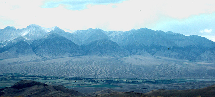
Slope change from steep to gentle in the land surface could lead to the reduction of stream carrying capacity and accumulation of deposition at the base of the slope, usually in the form of alluvial fans or coalesced alluvial fans (see Figure 2). The slope change could be caused by tectonic uplift, faulting, or differential erosion between two types of rock with different erodibility.

Figure 2
Aerial view of Lost River Mountains, alluvial fan, and floodplain of Big Lost River, Butte and Custer counties, Idaho, U.S.A.
(Source: http://www.gly.uga.edu/railsback/FieldImages.html)

Please continue to read about How WILSIM works


HomeIntroductionHow it worksTutorialAnimationExercisePost-TestGlossarySurvey
NIU HomeNSF HomeGeography HomeCSCI Home